
| Advancing global-scale hydrological modeling and the understanding of the global freshwater system by model development and calibration/data assimilation |
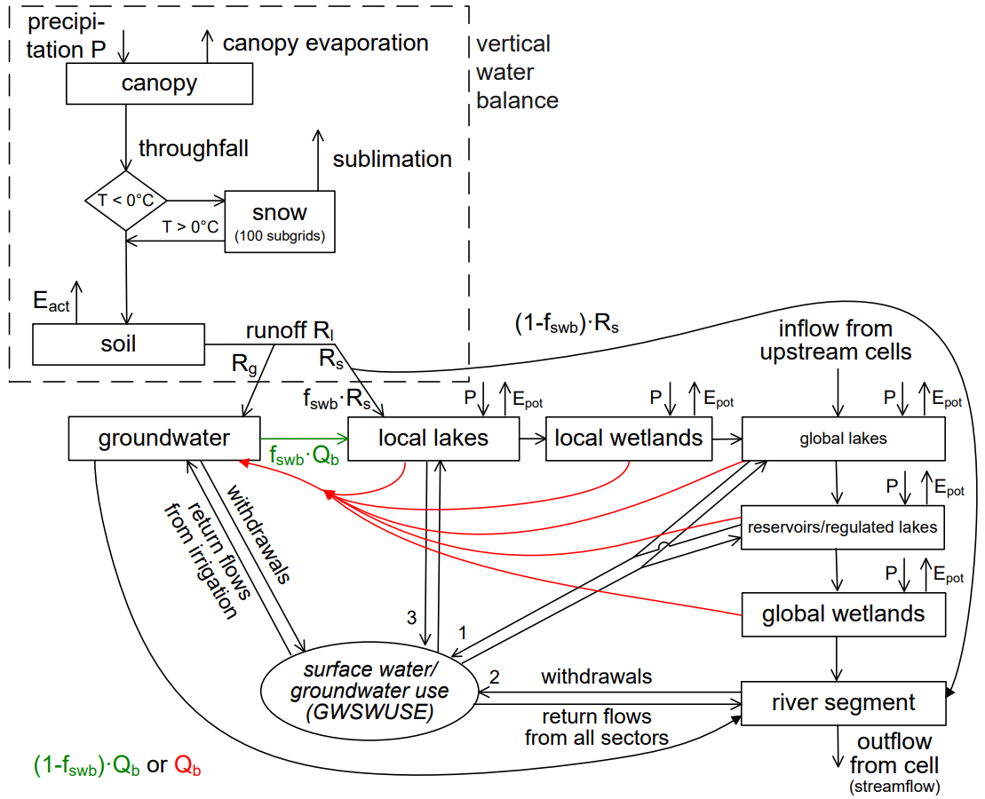
Within GlobalCDA, the goal of project P2 is to contribute to the development of a flexible calibration and data assimilation (C/DA) approach for the state-of-the-art global hydrological model WaterGAP that will enable WaterGAP (related publications) to better simulate water flows and storages by making best use of multiple observational data for model output variables. In this project, the WaterGAP 2.2d is used. WaterGAP 2.2d computes continental water fluxes (streamflow, groundwater recharge, actual evapotranspiration, and renewable water resources) and storages (in snow, soil, groundwater and surface water bodies as well as in glaciers) for the land area except Antarctica.
The proposed project P2 will:
1) contribute to the design of C/DA experiments with the WaterGAP Global Hydrology Model as well as to the evaluation of the developed C/DA approach. C/DA is to obtain the optimal benefit from observational data for WaterGAP output variables, by identifying optimal spatially resolved model parameter estimates and by deriving best estimates of historical water flows and storages, while helping to improve our understanding of the impact of model structure on model outcomes
2) advance the capability of WaterGAP to model globally relevant freshwater-related processes. These processes include a) the interaction of groundwater and surface water bodies and capillary rise which are to be simulated by a global gradient-based groundwater model, b) dynamic inundation of floodplains and c) simulation of the impact of glacier water balances on water flows and storages. Model development, in particular of the groundwater model, is to be supported by rigorous sensitivity analysis
3) improve our understanding of WaterGAP model output uncertainties (after C/DA) related to the quantification of freshwater flows and storages, by synthesizing information from ensemble-based EnCDA and POC as well as validation studies, and
4) assess ensembles of WaterGAP model output after C/DA for providing best estimates and uncertainty characterization of water storages and flows in five large critical regions/river basins, with a focus on the Tigris-Euphrates-Western Iran region.
