
| GlobalCDA – Research Project Funded by |


| The final meeting of our research project took place in March 2024. We would like to thank all participants and supporters for their commitment and contributions. From now on, this website will no longer be updated. For further information or inquiries, we remain at your disposal. |
What our researchers are saying:
Jürgen Kusche
Professor at the University of Bonn
Satellite geodesy provides unique observations of large-scale water mass change and thus, of climate variability, climate change and anthropogenic processes. Our group works on new methods for integrating measurements of the Earth’s gravitational field variations in space and time with hydrological and land surface models. GlobalCDA has been a great place to collaborate with experts in various space observation techniques and with hydrological modellers, to pursue the integration of geodetic and remote sensing data with numerical models. It has been instrumental in educating a new generation of scientists.
Petra Döll
Professor at the Goethe University Frankfurt/Main
Given the scarcity of in-situ observations that are available for understanding how water flows and is stored on the continents of the Earth, combining global-scale hydrological models and satellite data is paramount for assessing the global freshwater system. In GlobalCDA, I have learnt a lot about satellite data and their uncertainties and how these uncertain data can be used to advance global hydrological modeling.
Denise Dettmering
Scientific Researcher at the Deutsches Geodätisches Forschungsinstitut at the Technical University of Munich (DGFI-TUM)
In our group at DGFI-TUM, we have been working for more than 10 years on the processing and analysis of satellite altimetry data to derive accurate lake and river water levels. The interdisciplinary collaboration in GlobalCDA has helped to optimise the data for use in global hydrological modelling and to better understand their advantages and limitations compared to ground-based measurements.
Nico Sneeuw
Professor at the University of Stuttgart
Hydrological modelling notoriously suffers from a lack of synoptic observations. It therefore made perfect sense that hydrology teamed up with satellite geodesy within GlobalCDA. Geodesists usually have a thorough understanding of the quality of their data, be it from satellite gravimetry, satellite altimetry or classical remote sensing. But to make those data work for a global hydrological model and to see how these data constrain the global water cycle has been both an arduous and a very rewarding effort. In this respect the collaborations between the GlobalCDA participants have been very stimulating and beneficial.
Mohammad Tourian
Scientific Researcher at the University of Stuttgart
The undeniable lack of in-situ data to understand the Earth system is no longer up for debate. I enjoyed participating in the GlobalCDA project as it provided a platform for estimating numerous hydrological parameters from space, including river and lake water levels, river discharge, and surface water storage. I furthermore liked GlobalCDA since it offered the possibility to incorporate these spaceborne parameters into a full-fledged hydrological model, which would lead to a better understanding of the hydrological cycle. Despite facing numerous challenges, our achievements stand as truly remarkable.
Kerstin Schulze
Scientific Researcher at the University of Bonn
Participating in interdisciplinary research has been a captivating venture. As a geodesist, delving into the complexity of hydrology and hydrological modeling with experts proved immensely enlightening. The opportunity to participate in project coordination not only broadened my understanding of project management but also provided practical insights. This research project integrated diverse fields, expanded my knowledge and enhanced my practical expertise.
Helena Gerdener
Scientific Researcher at the University of Bonn
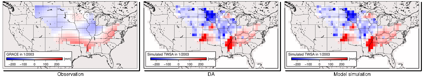
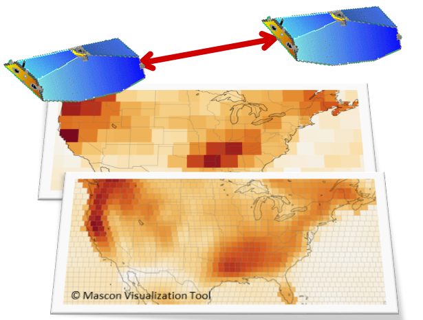
Measuring water changes from space is a great opportunity to globally monitor interesting water-related events and flows between water storages. During the project, I used the gravity missions GRACE and GRACE/-FO. I learned how to process the mission’s data, how to integrate the satellite observations into hydrological models globally and its chances for the drought monitoring. I especially liked to gain knowledge of other observation types and simulations of water compartments in GlobalCDA and how they can jointly be used to improve our understanding.
Seyed Mohammad Hosseini Moghari
Scientific Researcher at the Goethe University Frankfurt/Main
In this project, my primary focus is on model calibration and development, particularly within a large-scale reservoir operation scheme. The collaboration among diverse GlobalCDA teams has the potential to explore uncharted realms in hydrology science, providing a deeper understanding of the water cycle under anthropogenic alterations. I firmly believe that partnering with remote sensing teams is pivotal in removing data availability constraints for calibrating hydrological models. This experience has been an invaluable learning journey, expanding my proficiency in high-performance computing and adeptly handling uncertainties in observed data to enhance hydrological modeling.
Sebastian Ackermann
Scientific Researcher at the Goethe University Frankfurt/Main
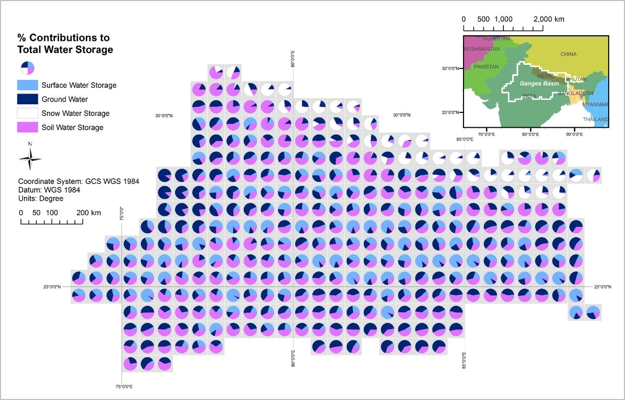
I undertook the challenging task of coupling the global groundwater model G3M with the global hydrological model WaterGAP to enhance our understanding of worldwide groundwater availability. In an era where climate change threatens the sustainability of this vital resource, my project aimed to shed light on often overlooked groundwater dynamics. The crucial need for obtaining more precise data, or any data at all, cannot be overstated. I hope that this endeavour will contribute to a deeper understanding, fostering more informed water resource management in the ever-evolving context of global climate challenges.
Daniel Scherer
Scientific Researcher at the Deutsches Geodätisches Forschungsinstitut at the Technical Universtiy of Munich (DGFI-TUM)
Working in a diverse research unit with scientists from different backgrounds was a great experience. I learned a lot about the requirements, methods, and perspectives of scientists from other fields. It was rewarding to see our data help other scientists. We had many seminars on both science and soft skills, which enriched our work and personal development. The diversity of our team added depth to our discussions. This project was an excellent opportunity to see the impact of our research.
Omid Elmi
Scientific Researcher at the University of Stuttgart
Remote sensing techniques play a pivotal role in advancing our understanding of terrestrial water storage dynamics and their intricate relationship with the hydrological water cycle and climate change. Our project focuses on developing data sets that track changes in surface water storage of inland water bodies using satellite altimetry and imagery data.
Collaborating with the GlobalCDA research unit provides a valuable opportunity to work alongside hydrological modelers. Together, we aim to integrate remote sensing data with numerical models, improving our ability to predict and understand changes in the global freshwater system and its response to climate change.
Patrick Sogno
Scientific Researcher at the German Aerospace Center (DLR)
Understanding the dynamics of surface water hydrology and snow cover is key to developing accurate hydrologic models. With this background, our team developed datasets for global surface water and snow cover analysis, each with daily temporal resolution. In GlobalCDA, we focused on the development of uncertainty estimates for these products. As such, our time series can be used as observation-based inputs to enhance hydrological models and assess surface water resources in critical regions.
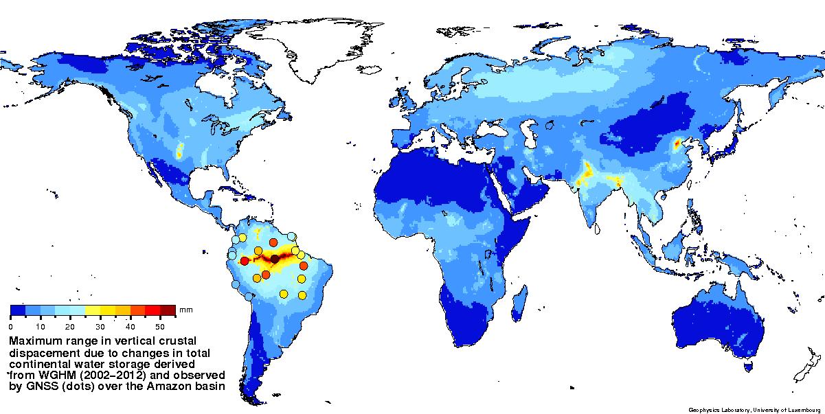
Majid Abbaszadeh
Scientific Researcher at the University of Luxembourg
My main expertise lies in generating precise geodetic information from Global Navigation Satellite System (GNSS) data. GlobalCDA helped me to learn about the crucial role of GNSS-derived time series for hydrological model validation. It also offered an opportunity for collaboration with individuals from different scientific backgrounds. Now, I have a better understanding of the physical modeling of hydrological storage/flux, the coupled interaction between climate change and hydrological cycles, and data assimilation techniques, all of which will be highly beneficial for my hydrogeodesy career in the future.